Region 3 Dove Fields
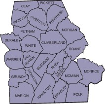
Crop status and leased fields as of August 26, 2024. Leased fields will be posted by county and listed below the WMA fields the last week of August. Please check this page often for changes and additions.
- Remember shotgun plugs and Migratory Bird Permit
- Hunter Education is required for those born on or after January 1, 1969
- Unless otherwise listed, dove hunting is open with statewide seasons and bag limits
Private lease fields are only open on the listed hunt dates. Please do not visit fields until the day of the hunt.
Capacity may be limited on some fields depending on hunter turnout.
Wildlife Management Areas
Crops planted: 35 acres total: 8 acres wheat bush hogged; 5 acres millet; 22 acres bush hogged
Hunt dates: Sept 1 (at noon). Same as the statewide season.
Directions: From Sparta travel south on Mayberry Street 3 miles, turn left onto Hwy 111 and merge onto US70 for about a mile; turn left onto Panther Drive for 0.4 mi, turn right onto Hickory Valley for 7.5 mi, continue straight to Big Bottom Rd for 2.4 mi
GPS Coordinates: N 35.8213, W -85.37745
WMA Small Game Permit required.
WMA Map (zoom in to see dove field) and Google Map Directions.
Crops Planted: 8 acres total: 8 acres millet bush hogged; 6 acres wheat top sown
Hunt dates: Sept 1(at noon). Opens at 12 p.m. on opening day.
Directions: From I-40, take exit 320. Turn North on to Genesis Rd (TN-298). Drive 5.3 miles and turn right on to Fox Creek Trl. Field is immediately on the left inside the gate.
GPS Coordinates: N 36.0439678, W -84.96106071
WMA Small Game Permit Required.
WMA Map (zoom in to see dove field) and Google Map Directions.
Crops Planted: 40 acres total: 15 acres sunflowers bush hogged; 20 acres millet burned
Hunt dates: Sept 1(at noon). Opens with statewide season
Directions: From Gainesboro...Head north on TN-53 N/TN-56 N toward Celina and travel
1.2 miles. Turn left onto HWY TN-56 (Jennings Creek Hwy) and travel 4.0 miles. Turn left onto TN-85 W. Travel 0.3 mile and Turn right onto Draper Hollow Ln. travel 0.4 mile
GPS Coordinates: N 36.42470706, W -85.67459727
WMA Small Game Permit Required.
WMA Map (zoom in to see dove field) and Google Map Directions
Crops Planted: 60 acres total: 30 acres sunflowers bush hogged; 15 wheat top sown
Hunt dates: Sept 1(noon) adult--Noon to sunset, non-toxic shot; Sept 14th Youth date; Sept 19th adult.
Directions: From Dayton on Hwy 60 turn onto Shadden road, turn right onto Blythe Ferry road and then left onto Priddy lane.
GPS Coordinates: N 35.39874015, W -84.99268639
WMA Small Game Permit Required.
WMA Map (zoom in to see dove field) and Google Map Directions
Crops planted: 28 acres total: 15 acres sunflowers bush hogged; 9 acres millet bush hogged
Hunt dates: Sept. 1 by hand-held drawing. Sept. 2 through remainder of statewide season, same as statewide regulations. Drawing to be conducted on August 24 at Independence Community Center. Drawing sign-up beigins at 4 p.m. local time. Drawing will be held at 5 p.m. local time. Hunters must be present to be drawn.
Directions: From Livingston, Take Hwy 111 North toward Byrdstown. Travel 3.6 miles to Hwy 294 (Willow Grove Hwy). Turn left and travel 5.2 miles. Turn left on Independence Road. Travel 0.4 mile and the WMA is on the right.
GPS Coordinates: N 36.49200054, W -85.29991862
WMA Small Game Permit required.
WMA Map (zoom in to see the dove field) and Google Map Directions.
Crops planted: 8 acres total: 4 acres buckwheat burned; 4 acres millet burned.
Hunt dates: September 1 & 2 noon to sunset only on Sept. 1. Noon to sunset only on 9/1. Avoid damaging the powerline and cables service lines that cross the field. Avoid firing on the direction of the residence located in the private in-holding.
Directions: From Kingston Hwy 70 towards Midtown, turn onto Bluff Road, turn left onto Bowman Bend Road, field on left hand side of the road once you reach the WMA.
GPS Coordinates: N 35.84703269, W -84.55765968
WMA Small Game Permit required.
WMA Map (zoom in to see dove field) and Google Map Directions
Crops planted: 21 acres total: 1 acres wheat bush hogged; 16 acres sunflowers bush hogged; 4 acres millet bush hogged
Hunt dates: Same as statewide seasons. Noon to sunset only on Sept. 1.
Directions: From Smithville, Tennessee take TN-146 S for 8.7 miles, then make a sharp right onto Pea Ridge Road, travel 5.0 miles, and turn right onto Herman Road.
GPS Coordinates: N 35.93117, W -85.94275
WMA Small Game Permit required.
WMA Map (zoom in to see dove field) and Google Map Directions
Crops planted: 7 acres total: 3 acres corn bush hogged; 4 acres buchwheat bush hogged
Hunt Dates: Sept 1 at noon. Open with the statewide season. Must pick up all empty shotgun hulls and trash when leaving.
Directions: From the main entrance of Prentice Cooper WMA drive approximately 1/2 mile till you see dove field signs on your left.
GPS Coordinates: N 35.15323881, W -85.41448841
WMA Small Game Permit is required.
Bow Field
Crops planted: 60 arces wheat top sown
Hunt dates: Sept. 1 (Noon), 2, 7 --- Opens at noon on Sept. 1. Do not shoot across the road or powerlines. Do not leave litter or hulls in field. Mind safety zones. There are 2 fields across the road from each other.
Directions: From I-40 exit 338 (Westel Rd.), drive South on Westel Rd. 0.5 miles, then turn right onto Pig Path Rd. 1.6 miles. Turn right onto Millstone Mountain Rd. (stay left at the split) 1 mile, Turn left into field gravel parking lot.
GPS Coordinates: N 35.91087, W -84.77327
WMA Map (zoom in to see dove field) and Google Map Directions
Wilson
Crops planted: 40 acres of chopped corn and top sown wheat
Hunt dates: Sept 1 (Noon), 2, 7 Field south of the driveway along the southern edge of the leased field is not included in the lease. No hunting, parking, or driving in that area.
Directions: From I-75 turn on Hwy 163. turn toward the east and travel for approximately 2.4 miles to US-11S. Go North on US-11S for approximately 3.5 miles and arrive at marked field.
GPS Coordinates: N 35.348462, W -84.7143193785
WMA Map (zoom in to see dove field) and Google Map Directions
Farr
Crops planted: 40 acres corn chopped and wheat top sown
Hunt Dates: Sept. 1 (Noon), 2, 7
Directions: From I-75 near Athens, TN exit onto TN 305 (John Duncan Parkway). Travel west to County Road 250 (Pond Hill Road). On Pond Hill Road drive 3.8 miles to marked field.
GPS Coordinates: N 35.555489, W -84.61346866
WMA Map (zoom in to see dove field) and Google Map Directions
Harrison Farm
Crops planted: 40 acres of chopped corn and top sown wheat
Hunt dates: Sept 1 (Noon), 2, 7 Stay inside marked area; a portion of the harvested field is not included in the lease and will be marked.
Directions: From Sweetwater TN, travel east on Hwy. 322 for approximately 7.3 miles, turn onto Seed Tick Road, travel 1.9 miles to Eve Mill Road, travel 3/10ths to field marked on the right.
GPS Coordinates: N 35.63821, W -84.32573
WMA Map (zoom in to see dove field) and Google Map Directions
Plemons Field
Crops planted: 40 acres corn chopped and wheat top sown
Hunt Dates: Sept. 1 (Noon), 2, 7 Parking area is across Maxwell road from hunting lease. Field used for parking is not included in the lease.
Directions: Hwy 411 in Madisonville Tn, travel south on HWY 411 for 2.8 miles to Maxwell Road. Drive approximately 1/2 miles to the marked field and parking area.
GPS Coordinates: N 35.4841022, W -84.3927900
WMA Map (zoom in to see dove field) and Google Map Directions
Sparkman Farm
Crops planted: 50 acres corn chopped
Hunt dates: Sept 1 (Noon), 2, 7 Field opens at noon on Sept 1. Do not drive in field. Do not shoot powerlines. Watch for safety zones. There are 2 fields across road from each other. Do not litter or leave hulls in field.
Directions: From Sparta, drive South on McMinnville HWY. for 4.4 miles. Turn right onto Franks Ferry Rd. for 1 mile. Turn left onto Disneyland Rd. for 0.7 miles. Turn right onto Eaton Rd. for 0.5 miles. There is a 40 acre field on the right and 10 acre field on left.
GPS Coordinates: N 35.87206, W -85.52968
WMA Map (zoom in to see dove field) and Google Map Directions